
Mongolia Weather, climate and geography
Weather & climate
Mongolia has a continental climate with long, cold winters and short, warm summers. Temperatures vary wildly from season to season. Much of the country is a large plateau with an average elevation of 915m to 1,524m (3,000ft to 5,000ft) and subject to strong winds, especially in spring. The best time to visit Mongolia is from May to September when the days are warm – but do bring waterproofs as this period is also rainy.
Ulaanbaatar is the capital and sits at 1,300m (4,250ft) above sea level. Due to its elevation and latitude, spring arrives late in April in Ulaanbaatar. The average high in April is 8°C (46°F) while the average low is -5°C (23°F). Summer is warm but rainy – June is the wettest month with 50mm (11 inches) of rain in one month. Temperatures drop quickly after September and by November, the average high is below freezing at -5°C (23°F). Winter is cold – Ulaanbaatar is the coldest capital city in the world on average. In January, the average high is -16°C (3°F) while the average low is -29°C (-20°F).
The Gobi Desert is located in the south of Mongolia; hence it is slightly warmer than Ulaanbaatar. In Sainshand, in the eastern Gobi desert steppe, July is the warmest month with an average high of 29°C (84°F) and an average low of 17°C (63°F). Temperatures drop quickly after September too and by January, the average high is -12°C (10°C) and the average low is -23°C (-9°F).
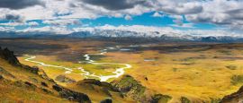
Geography
Mongolia has a 3,485km (2,165-mile) border with the Russian Federation in the north and a 4,677km (2,906-mile) border with China in the south. Much of the country is a large plateau with an average elevation of 915m to 1,524m (3,000ft to 5,000ft). Then there are three mountain ranges - Altai Mountains dominate the northern and western areas, the Khangai Mountains is almost at the centre but more towards to the west, while Khentii Mountains in north-eastern Mongolia. The Gobi Desert, a rocky desert with a thin layer of shifting sand, covers the southern part of the country.
The Khülten Peak, within the Altai Mountains range, is the highest peak at 4,374m (14,350ft). Hoh Nuur, a lake, is the lowest point that lies at 560m (1,837ft) in the east. There are several hundred lakes in the country as well as numerous rivers, of which the Orkhon River is the longest at 1,124km (698 miles).
Do you have any Feedback about this page?
© 2026 Columbus Travel Media Ltd. All rights reserved. No part of this site may be reproduced without our written permission, click here for information on Columbus Content Solutions.


 You know where