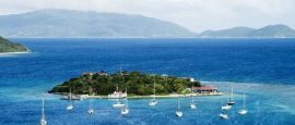
British Virgin Islands Weather, climate and geography
Weather & climate
The climate is subtropical and tempered by trade winds. There is little variation between summer and winter. Rainfall is low, varying slightly from island to island. Night-time temperatures drop to a comfortable level. Visitors should note that the British Virgin Islands are susceptible to hurricanes and earthquakes, although these are by no means a frequent occurrence. The primary hurricane season is from June to November.
Geography
The 50-plus islands, rocks and cays of the British Virgin Islands, only 16 of which are inhabited, make up the larger part of an archipelago forming the northern extremity of the Leeward Islands in the eastern Caribbean. They are situated approximately 100km (62 miles) east of Puerto Rico, adjoining the US Virgin Islands. The islands are volcanic in origin, with the exception of Anegada, which is formed of coral and limestone and is the lowest lying. The topography is otherwise mountainous, the highest point being Tortola's Sage Mountain, which rises to 550m (1,800ft). There are remnants of a primeval rainforest on Tortola.
Do you have any Feedback about this page?
© 2026 Columbus Travel Media Ltd. All rights reserved. No part of this site may be reproduced without our written permission, click here for information on Columbus Content Solutions.


 You know where