
Tanzania Weather, climate and geography
Weather & climate
Tanzania has a tropical climate with distinct dry and rainy seasons rather than four traditional seasons. Temperatures are generally warm throughout the year, with variations depending on altitude and location. Coastal areas and islands such as Zanzibar are hot and humid, while inland and highland regions, including Arusha and areas near Mount Kilimanjaro, are cooler and more temperate.
January to March is typically hot and dry, particularly in coastal and lowland areas, with daytime temperatures often ranging from 28–35°C (82–95°F). This period is popular for beach holidays, especially in Zanzibar, while inland regions remain warm but slightly less humid.
March to May marks the long rainy season, when heavy and sometimes prolonged rainfall can occur, especially in the north and along the coast. Temperatures remain warm, generally between 25–30°C (77–86°F), but travel in some areas may be affected by muddy roads and reduced accessibility.
June to October is the main dry season and generally considered the best time to visit. Temperatures are more moderate, typically 20–28°C (68–82°F), with cooler conditions in the highlands where evenings can be chilly. Wildlife viewing is particularly good during this period.
November to December brings the short rains, which are usually lighter and less predictable than the long rains. Showers tend to be brief, and temperatures begin to rise again, particularly in coastal regions where they range from 25–32°C (77–90°F).
Clothing in Tanzania should be chosen with both the climate and local customs in mind. Lightweight, breathable fabrics such as cotton and linen are suitable for most of the year, particularly in coastal and lowland areas where temperatures can be high and humidity is common. Sun protection is important, so a wide-brimmed hat, sunglasses and high-factor sunscreen are recommended.
During the dry season (June to October), days are generally warm but mornings and evenings, especially in highland areas such as Arusha or near Mount Kilimanjaro, can be cool. A light jacket or sweater is advisable. In contrast, the hotter months from January to March require lighter clothing, though an extra layer may still be useful for early-morning safari drives.
Rainy seasons occur from March to May (long rains) and November to December (short rains). A lightweight waterproof jacket or raincoat is advisable during these periods, along with footwear suitable for wet or muddy conditions, particularly in rural or safari areas.
Modest dress is recommended, especially in rural areas and along the coast, where there is a strong Muslim influence. Both men and women should avoid overly revealing clothing outside beach resorts. A light scarf or shawl can be useful when visiting religious sites.
Comfortable walking shoes are essential for exploring towns, national parks and uneven terrain. For safari trips, neutral-coloured clothing is recommended, and long sleeves and trousers can help protect against sun and insect bites.
Geography
Tanzania lies in East Africa, bordered by Kenya and Uganda to the north, Rwanda, Burundi and the Democratic Republic of the Congo to the west, and Zambia, Malawi and Mozambique to the south. To the east, it has a long coastline along the Indian Ocean, dotted with islands including Zanzibar, Pemba and Mafia, which are known for their beaches and marine life.
The country's geography is remarkably varied, offering everything from vast savannahs to towering mountains and deep lakes. Northern Tanzania is dominated by the Great Rift Valley and some of Africa's most famous landscapes, including the Serengeti plains and the Ngorongoro Crater. The central region consists largely of a high plateau, while the south and west feature more remote wilderness areas, including miombo woodlands and river systems.
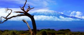
Tanzania is home to Africa's highest point, Mount Kilimanjaro, which rises to 5,895m (19,341 ft) above sea level. Despite being close to the equator, its summit is permanently snow-capped and attracts climbers from around the world. In contrast, the country's lowest point is at sea level along the Indian Ocean coast.
Several of Africa's largest lakes form part of Tanzania's borders. Lake Victoria, the continent's largest lake, lies in the north-west, while Lake Tanganyika in the west is one of the deepest lakes in the world. Lake Nyasa (also known as Lake Malawi) stretches along the southern border. These lakes not only shape the landscape but also support local livelihoods and offer opportunities for exploration.
Do you have any Feedback about this page?
© 2026 Columbus Travel Media Ltd. All rights reserved. No part of this site may be reproduced without our written permission, click here for information on Columbus Content Solutions.


 You know where