
Eswatini (Swaziland) Weather, climate and geography
Weather & climate
Eswatini enjoys a pleasant subtropical climate, with distinct seasons influenced by its varied topography. The country experiences warm, wet summers (October to March) and cool, dry winters (April to October). Temperatures and rainfall vary across regions:
Highveld: Cooler and wetter, with summer temperatures averaging 20–25°C (68–77°F) and winter temperatures dropping to 5–15°C (41–59°F). This region receives the most rainfall.
Middleveld: Warmer and less wet, with summer temperatures around 25–30°C (77–86°F) and mild winters averaging 10–20°C (50–68°F).
Lowveld: Hotter and drier, with summer temperatures reaching 30–35°C (86–95°F) and winter temperatures around 15–25°C (59–77°F).
When to visit Eswatini depends on personal preferences and planned activities. The wet summer season, from October to March, brings lush greenery and an abundance of birdlife, making it a prime period for bird enthusiasts. However, as Lowveld can get uncomfortably hot during this time, hikers should start early to avoid the intense midday heat and the frequent afternoon storms. Heavy rains may also disrupt activities like white-water rafting and caving.
The dry winter season, from April to October, offers cooler and more predictable weather, making it ideal for wildlife viewing, as the lack of dense vegetation improves visibility. This period is also perfect for outdoor adventures like white-water rafting. Additionally, visitors during this time can experience two of Eswatini's most iconic cultural events: the Bushfire Festival in May, a vibrant celebration of performing arts and music, and the Umhlanga (Reed Dance) in late August or early September, which showcases the nation's rich traditions and cultural heritage.
Lightweight, breathable clothing is recommended for Eswatini's warm summer months (October to March), along with a hat and sunscreen to protect against the sun. During the cooler, dry winter months (April to October), pack layers such as a light jacket or sweater, especially for mornings and evenings, which can be chilly in the Highveld.
Comfortable walking shoes are essential for exploring the country's nature reserves and hiking trails. If visiting cultural or religious sites, modest clothing is appreciated, and covering shoulders and knees is advisable. Don't forget a waterproof jacket if travelling during the rainy season.
Geography
Eswatini (formerly Swaziland) is surrounded by South Africa to the north, west, and south—mainly by the Mpumalanga and KwaZulu-Natal provinces—and to the east by Mozambique.
The country is defined by five main topographical regions:
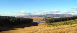
• Highveld (Inkangala): A wide ribbon of rugged terrain, partly reforested with areas like the Usutu pine forest.
• Peak Timbers: Found in the northwest, this area features densely forested landscapes.
• Middleveld: Rolling down from the Highveld, this region is characterised by hills and fertile valleys, supporting much of the country's agriculture.
• Lowveld (Bush Country): A low-lying area with altitudes between 170 and 360m (560 to 1,180ft), known for its savannah-like terrain.
• Lubombo Plateau: An escarpment along the eastern fringe of the Lowveld, consisting mainly of cattle grazing land and mixed farmland.
Eswatini is also traversed by four major rivers—the Komati, Usutu, Mbuluzi, and Ngwavuma—which play a crucial role in its ecosystems and agriculture.
Do you have any Feedback about this page?
© 2026 Columbus Travel Media Ltd. All rights reserved. No part of this site may be reproduced without our written permission, click here for information on Columbus Content Solutions.


 You know where