Best for
| Yes | Beginners | No | Non-skiers |
| Yes | Intermediates | Yes | Après ski |
| No | Experts | No | Summer skiing |
| Yes | Snowboarders | No | Snow reliability |
| Yes | Families | No | Environmental awareness |
Book and Go

Latest features


Saalbach-Hinterglemm ski resort
Ski runs
Beginner runs:
34
Intermediate runs:
28
Advanced runs:
6
Total runs:
68
Ski lifts
Chairs:
22
Drags:
20
Gondola cable cars:
28
Total lifts:
70
Parks:
2
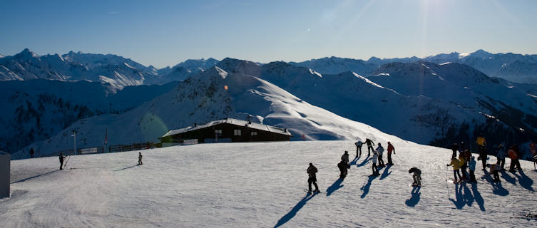
Saalbach-Hinterglemm ski resort has one of Austria's biggest ski areas on its doorstep with some of the finest intermediate pistes anywhere in the Alps. These ski slopes are located on both sides of the Glemm Valley, which enables skiers to easily complete a circuit of what the resort calls its ‘Ski Circus’ in a single day.
During the 2015/16 season a major investment saw the ski area connect across the Sazburgerland/Tirol provincial border to the smaller ski area of Fieberbrunn, to create - for that season at least - Austria’s largest ski area, with 270km (168 miles) of piste. It was itself overtaken a year later however, when the two halves of the Arlberg region were also connected to create Austria’s new biggest ski area for winter 2016-17. In short, Saalbach-Hinterglemm is well connected.
But all this modernisation hasn’t killed the resort’s soul, and visitors can still witness a slice of picturesque rural Austria when strolling around the village bases. At one end is Saalbach, a classic Austrian village with an onion-domed church, cobbled streets and a lively night-time scene; while at the other, about 4km (2.5 miles) away, is the smaller and more relaxed village of Hinterglemm.
Together, the settlements make an upmarket (but surprisingly youthful) spot that successfully mixes heritage and beauty with modern infrastructure and challenging terrain.
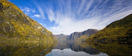
Saalbach-Hinterglemm is located in the Glemm Valley, which is within the Zell am See region in the Austrian Kitzbühel Alps. The ski resort is within 90 minutes' drive of Salzburg.
Slope Elevation
Saalbach-Hinterglemm
Resort:
1000m
Top:
2095m
Base:
930m
On the slopes
More than 90% of the ski area in Saalbach-Hinterglemm ski resort is rated intermediate or easy, so this is a place for letting the skis run through delightful tree-lined scenery on mainly south-facing slopes.
Taking on the Ski Circus circuit makes for a great day’s skiing, with lunch taken at one of the 44 mountain restaurants, including many delightful old huts.
Otherwise, it’s possible to concentrate on just one area – better skiers use Schattberg Ost, where the 4km (2.5 miles) Nordabfahrt is a fast, steep black with constantly changing conditions. The World Cup downhill on Zwölferkogel is enjoyable too, and it's here that good skiers can make their own fun on copious off-piste terrain.
There are also three terrain parks here, and the ski resort as a whole works well for snowboarders with the easy-to-ride lift network and a variety of runs for all levels.
Saalbach-Hinterglemm is also a resort where skiers and boarders can get back up the slopes quickly. In fact, there are more comfortable, high-capacity gondolas and high-speed chairlifts here than any other single resort on the planet.
Although Saalbach-Hinterglemm ski resort is not high, an ever-increasing amount of snowmaking (now covering 90% of the slopes) keeps everything going so long as it’s cold enough for the guns to operate. Saalbach's south-facing nursery areas can get slushy at the start and end of the season, but Hinterglemm's slopes are north facing, ensuring greater reliability in snow cover.
The ski season in Saalbach-Hinterglemm runs from early December until early April.
Average snow depth in Saalbach-Hinterglemm
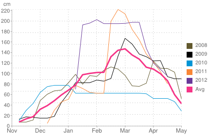
Historical snow depth in Saalbach-Hinterglemm
Do you have any Feedback about this page?
© 2026 Columbus Travel Media Ltd. All rights reserved. No part of this site may be reproduced without our written permission, click here for information on Columbus Content Solutions.


 You know where