Book and Go

Latest features


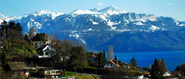
Weather in Bern
Bern has a humid continental climate characterised by warm summers and cold winters. Spring (March to May) sees temperatures gradually increase from 5°C (41°F) to 12°C (54°F).
Summer (June to August) is the peak season for tourism as temperatures in Bern typically hit highs of 23°C (73°F). This is a popular season for walking, hiking and cycling tours around the city. The River Aare becomes a popular spot in summer as locals and tourists go rafting along the river, seeing the city from a unique and unusual perspective.
Autumn (September to November) is mild with the average temperatures reaching highs of 19°C (66°F) in September and 8°C (46°F) in November.
Winter (December to February) can be frigid as the average temperature typically reaches lows of -2°C (28°F) in December. However, the Christmas markets dotted around the city makes the season more enjoyable. The main Christmas markets can be found in Münsterplatz and Waisenhausplatz.
https://en.climate-data.org/europe/switzerland/bern/bern-55/
Night
| Weather (night) | Temp (min night) | Rain (mm) | Wind (mph) | Humidity Pressure Visibility | ||
|---|---|---|---|---|---|---|
| Mon |
Clear
|
Clear skies |
1 3 °C |
0.6mm |
3
sse |
82%
1,019mb Good |
| Tue |
Partly Cloudy Night
|
Partly cloudy skies |
1 6 °C |
0.6mm |
3
s |
71%
1,019mb Good |
| Wed |
Occ Light Rain
|
Patchy rain possible |
1 4 °C |
0.6mm |
4
s |
92%
1,019mb Moderate |
| Thu |
Mist
|
Mist |
1 4 °C |
0.3mm |
3
sse |
95%
1,021mb Poor |
| Fri |
Mist
|
Mist |
1 3 °C |
0mm |
2
sse |
95%
1,019mb Poor |
| Sat |
Partly Cloudy Night
|
Partly cloudy skies |
1 5 °C |
0mm |
4
ssw |
74%
1,016mb Good |
| Sun |
Partly Cloudy Night
|
Partly cloudy skies |
1 2 °C |
0mm |
0
nnw |
95%
1,018mb Good |
| Mon |
Overcast
|
Overcast skies |
1 2 °C |
0mm |
5
ne |
75%
1,020mb Good |
| Tue |
Occ Light Rain
|
Light rain |
1 1 °C |
0mm |
4
ne |
97%
1,018mb Moderate |
Last updated at 04:06, Tuesday 27 August
View help
Close help
Last updated: We update the weather data for Bern from our weather partner every four hours. The time the last update was received is detailed here.
Actual Forecast Location: We have 830+ weather locations on the worldtravelguide.net website. Where no exact location is available we have used the nearest appropriate forecast point.
Symbols indicate the predominant weather for the day in question, calculated based on a weighting of different types of weather. So if a day is forecast to be sunny with the possibility of a brief shower, then we will see a sunny or partly cloudy symbol rather than a rain cloud. For the purpose of this forecast, 'day' is the entire 24 our period 00:00 to 23:59
The maximum temperature is the highest temperature forecast between dawn and dusk, and the minimum temperature is the lowest temperature expected from dusk on the day in question to dawn the next day. The temperature is in °C, or Celsius.
Wind speed and direction are the conditions expected at midday. Wind direction is based on a 16 point compass. W, SW, SSW, etc. The wind direction states where the wind originates. Wind speed is listed in MPH or miles per hour.
Humidity levels indicates how much water vapour the air contains compared to the maximum it could contain at that temperature. As a general guide:
- 0 to 30 is very low
- 31 to 50 is low
- 51 to 70 is moderate to low
- 71 to 80 is moderate
- 81 to 90 is moderate to high
- 91 to 100 is high
Pressure is measured in millibars (mb)
Visibility based on whether the human eye can see the following distances:
- Very poor - less than 1km
- Poor - between 1km and 4km
- Moderate - between 4km and 10km
- Good - between 10km and 20km
- Very good - between 20km and 40km
- Excellent - more than 40km
Close
Do you have any Feedback about this page?
© 2026 Columbus Travel Media Ltd. All rights reserved. No part of this site may be reproduced without our written permission, click here for information on Columbus Content Solutions.


 You know where